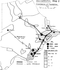
I was by that time a member of the National Telecommunications Commission and it was made very clear that we'd have to pay the full capital cost of any expansion of the "backbone" to carry our programmes - the figures looked horrendous. So we asked our ITU experts - one of whom, incidentally, owned his own vineyard in Switzerland! - to do the hard work of analysing the local topography and getting the best value for money out of any site that we might manage to put in. We had all kinds of wild schemes for the programme feed which ranged from rebroadcasting from one transmitter to the next in a chain of dubious reliability, to asking the local Information Officers to climb up the local hill and retune shortwave receivers twice a day.

Population map of Botswana, c.1978, showing some early programme distribution ideas
(Click for a larger image)

